
[Note: Click on any image you may want to enlarge.]
The complex entity people call “Onitsha” deserves respectful accounts — written, pictorial, aural, etc. — that illuminate its importance (ecological, demographic, historical, economic, political, aesthetic, religious, etc.) and that also record its stature as a long-suffering center of human as well as non-human existence. The website constructed here contributes toward that aim, recognizing as the Nigerian writer Chinua Achebe (who grew up in its urban environs during the 1930s) memorably stated, that some of the remarkable cultural contributions appearing in Onitsha in recent times may be best understood as emerging from within a “zone of occult instability”1.
Cultural “Instabilities”
Achebe was discussing “the amazing pamphlet literature of the Onitsha market” which came to the world’s attention in the 1950s, of which he says:
“One of the most intriguing questions concerning this literature — Why did it happen in Onitsha? — has however, not yet been answered fully and I suspect never will be…. It is this area which interests me — the esoteric region from which creativity sallies forth at will to manifest itself. All we can do is to speculate. Onitsha is such a phenomenon. Whenever I think of it, a phrase from Frantz Fanon comes immediately to my mind: a zone of occult instability.”

In more recent years, this “esoteric source of cultural creativity” has continued as, in the post-Biafra malaise of the 1990s, Onitsha played a germinal role in the rise of Nollywood Cinema (a richly-blossoming cosmos well worth exploring). Or consider a much smaller, perhaps unique efflorescence in the early decades of the twentieth century: the both hidden and celebrated self-re-creation of a very queer man who sometimes called himself “Jack O’Dazi”, a “palm-oil ruffian” who managed to thrive in Onitsha while defying both British Government and Roman Catholic authorities, establishing himself among Onitsha indigenes as an incarnation of the Saintly Mammy-Wata, Goddess of the Rivers and friend of the mighty Python (Eke). (He was sometimes referred to as “Eke-Young”.) His particular story has now been revealed to the world in this 2006 exemplar of Onitsha-brewed cultural brilliance, the book entitled The Forger’s Tale: The Search for Odeziaku, written by Stephanie Newell, a Reader in English Literature at the University of Sussex2. Her particular act of brilliant creation required both deep research engagement with Ndi-Onicha (“Onitsha people”) and much insightful effort elsewhere (the city of Manchester, England, for example).
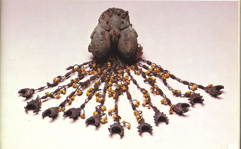
Another source of noteworthy cultural instabilities may be found in locations not far from Onitsha to the east, where an astonishing complex of cultural creativity appeared at the archaeological sites of Igbo-Ukwu and Oreri which date to somewhere around 800-900 A.D. We need look no further than Wikipedia for a succinct summary of how these finds have reverberated globally: “The Igbo-Ukwu bronzes amazed the world with a very high level of technical and artistic proficiency and sophistication which was at this time distinctly more advanced than bronze casting in Europe….” Frank Willett says that the Igbo-Ukwu bronzes portray a standard that is comparable to that established by Benvenuto Cellini five hundred years later in Europe. Denis Williams calls them “an exquisite explosion without antecedent or issue.”3 Williams nicely registers the current bewilderment of art historians as well as anthropologists: where did this complex come from, where did it go, and how has it affected Onitsha and other parts of the world?
We hope in this volume (“ethereal-onlly”,as it may be) to shed some further light on the sources of the “zone(s) of occult instability” that have manifested themselves in Onitsha and vicinity over the course of time(s). The rest of this chapter is just a beginning; many profound contradictions — sources of instability — lie much further ahead.
“Ancient Instabilities” (in Nature)

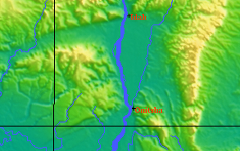
If you proceed to observe the location of Onitsha broadly enough over land and deeply in time, it reveals the presence of instabilities of a very different kind (some of which surely also fit the rubric of what today appears “occult”). Geographically, Onitsha’s position as a mere local flank of a very large river is almost unique: as you see from the image at left (roughly centered on Onitsha), where the city location is marked by a tiny red dot, it stands on the riverside edge of extensive uplands that spread out to the east, and also confronts an apex between two vast triangular floodplains, one spreading out northward (upstream from Onitsha) for 70 miles to its origin point near the contemporary city of Idah, the other (the immense Niger Delta, also still subsiding under the weight of accumulating sediment) expanding southward for more than 100 miles where its numerous, spreading “distributaries” eventually reach the sea4. When the Niger River first did that, it happened at the site now called Onitsha. The presence of extensive riverine “Deltas” both to the north and to the south of its coastal location is surely unusual, and “occult”.
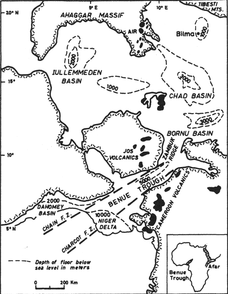
The geological processes that explain this topographic peculiarity relate to the fact that (during what likely seem to today’s residents of the city to be unimaginably ancient times) the physical earth of the entire region tore (“rifted”) apart, creating what geologists now call the “Benue Trough”. Geologists tell us that a rifting of the African continent partially spread open here, as shown on the map to the right, beginning in late Jurassic and early Cretaceous times, from some 150 to 130 million years ago (Ma) and continuing to 80 million Ma.5 The dotted lines marked “Chain F.Z.” and “Charcot F.Z ” refer to “Fracture Zones,” two of the major crustal breaks seen as underlying the rifting. This rift system (80 million years ago) was in part ancestral to the contemporary rifting evident in the Cameroon line of volcanoes further east, marked in black spots on the attached map .6.
The rifting shown here was a minor part of the much larger rift-expansion that built the Atlantic Ocean beginning during these times, and in some phases of this process the emerging Atlantic surged deep into this part of the African Plate, with seas extending sometimes northward into what is now Sahara Desert. Subsequently, the entire trough was subjected to a complex series of compressions, foldings and “twistings” that eventually produced (after many millions of years of intervening geological work) the unusual uplands-and-floodplains combination that we see on the ground today.7. This rifting and folding, later invaded by volcanics and hydrothermal mineral deposits, eventually gave rise to strata containing silver, lead, tin, and copper, materials crucially important to the people of Igbo-Ukwu who left behind the archaeological wonders we merely alluded to above.
We will pursue geological facts no further here (indeed, late 20th- and early 21st-century geology of this area seems almost as dauntingly complex as quantum physics does to the layperson now writing these words), but it’s worth noting that the Anambra Basin (part of the Anambra syncline, the Anambra Platform, eroding and then subsiding over a very long time) attains in some places sedimentary deposits many thousands of feet deep and contains substantial deposits of petroleum. The utterly flat alluvial floodplain that we see north of Onitsha today is merely part of the western edge of this much larger geostructural basin.
The dominant geomorphic feature of Onitsha’s much later prehistoric but now human situation is the Niger-Benue watershed, the expanse of which is shown on the map below (the also large Benue River runs from the east to meet the Niger at Lokoja):
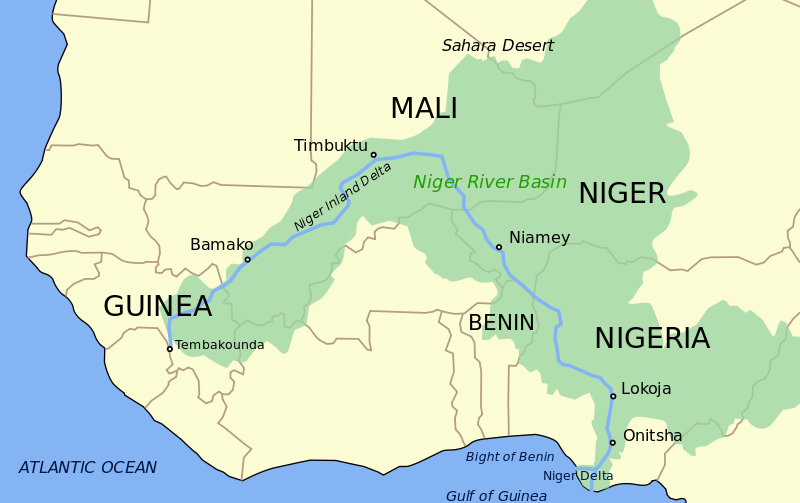
The combined length of these two rivers (note that the Benue extends well east of the Green outline shown here) far exceeds the distance across all 48 contiguous states of the United States of America. And the headwaters of each one lie in tropical uplands that receive the annual monsoons generated by the seasonal movements of the Intertropical Front: Both the Fouta Djallon and Loma Mountains of Guinea (prime headwaters of the Niger on the west) and the highlands of eastern Nigeria, Cameroon, and Chad (main sources of the Benue to the east) receive heavy rainfall from June through September, and sustain a relatively dry season from November through March.
This dictates a a regime of seasonally rising and falling volumes in the waters that carve their way through these great basins. Specialists in hydrology distinguish the floods that reach our Onitsha area according to their different sources, but the greatest annual flooding of the Lower Niger area comes in September and October of every year, and in the vicinity of Onitsha, the difference between high water and low water can reach as much as 35 feet.8 Despite the recent construction of numerous dams along the Niger tributaries, flooding of the Lower Niger valley lowlands still occurs, as can be seen in this satellite image from October of 2012 9:
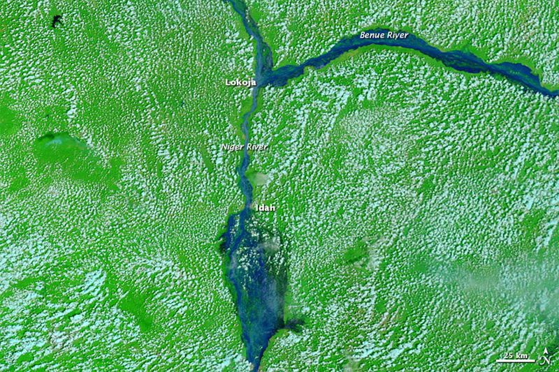
Onitsha lies at the bottom of the map. At the top, you can see that the Benue River is contributing the great mass of the flooding, which covers the entire Anambra Basin. (Note too the heavy contribution of the Anambra River, the dark streak running along the eastern side of this floodplain. Local rains contribute significantly to this seasonal flooding.) The Anambra (in Igbo, omambala, “plain floods”) floodplain is some 60 miles in length, and “in most years provides a wetland of 165,000 hectares” 10
This ancient geographical instability has been crucial to the livelihoods of the people who have become involved in this region, producing great imbalances as well as opportunities in modes of residence, livelihood, politics, and other features of life. Onitsha, whose origin, emergence, and development occurred within thus encompassing framework, came to be defined in terms of a basic contrast between “otu” (“waterside”) and enu (“highland”).
- Chinua Achebe, 1975, p. 153. Emphases added [↩]
- Newell 2006 [↩]
- Wikipedia, “Archaeology of Igbo-Ukwu”, retrieved Aug. 20, 2016. The sources cited in this quotation include Honour & Fleming 2005, Herbert 1984, Willett 1983, and Williams 1974. [↩]
- Hughes & Hughes 1992: 412-13. [↩]
- S. W. Petters, 1978. The map shown here is on page 312 of that text. [↩]
- See Fitton, J.G., 1981, The West African Rift System and its Bearing on the Origin of Continental Rifting, NASA Astrophysics Data System. [↩]
- See Benkhelil, J., 1989. Benkhelil says in his conclusion (p.281), “Compressional movements are responsible for the generalized folding of the Benue Trough but with a noticeable role of wrenching.” The diagrams presented in Figures 22 and 23 in this article give a much more detailed model of the processes inferred [↩]
- See Jennings and Oduah 1966:48 for a diagram of annual variation taken in 1953. [↩]
- Source: Earth Observatory [↩]
- Hughes & Hughes,p.416. [↩]