[Note: Click on any image you may want to enlarge.]
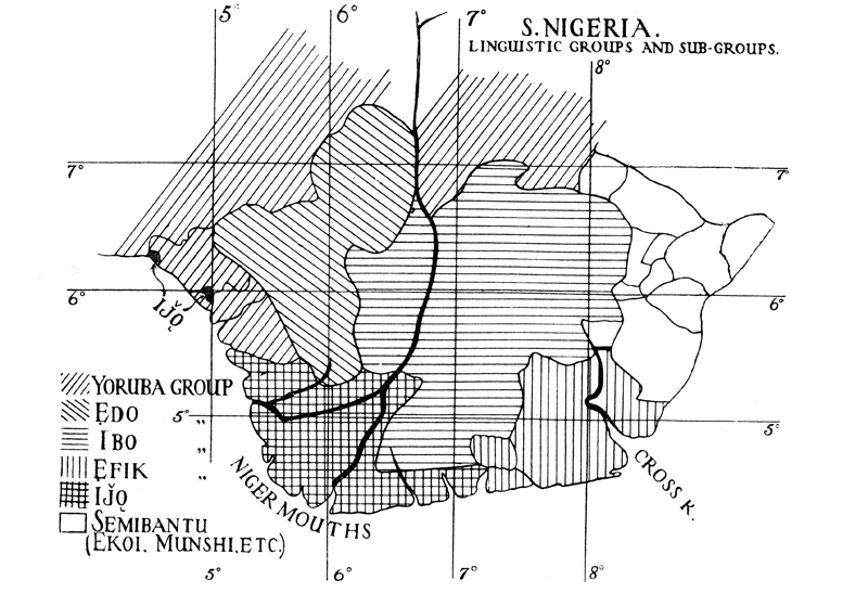
The distribution of language groups in the southern-Nigeria focal area of our concern shown above should remind us of the high quality of research done by early anthropologist-linguists who worked in that region more than a century ago. It’s noteworthy that so few identified both the named groupings and their (then-)current geographical distributions with such accuracy in an arena then so new to the gaze of social and cultural scientists.
Here I assume that most readers of these pages are scientifically-informed in a general sense but not experts in historical linguistics. My own formal linguistic training (historical and otherwise) was largely limited to a few courses given by Stanley Newman (a master linguist of his time, to be sure) in the Department of Anthropology at the University of New Mexico in the 1950s, but from that brief contact I did develop lasting respect for and interest in the science of linguistic reconstruction1.
In what follows I pick and choose from current sources that seek to organize the state of knowledge in the history of African languages, and try to relate these to information from other sources (climatology, archaeology, other histories, etc.), aiming to present historical findings relevant to Onitsha that will of course be provisional, subject to modification as knowledge and methodologies in these fields of research improve. I will speak of “history”, but much of this falls more accurately under the rubric “pre-history”, working with times and places lacking written historical records.
This is an exciting time for anyone interested in the history of Africa, as new and often startling information and interpretations continue to emerge. New syntheses are appearing, greatly transforming our views from the days when I was a new Ph.D. in Anthropology and George Peter Murdock’s Africa: Its Peoples and their Culture History (1959) was the latest attempt at a synthesis, but West African history has also become more complex and much remains highly controversial.
We might well be tempted to rely more strongly for an historical picture derived from archaeology, and will refer to findings from that field, but it too provides in many ways more questions than answers. The fields related to historical climatology are also very important, but these also show considerable variability. My perspective here, largely that of an amateur, will seek general views that seem reasonable in light of available evidence, recognizing that perspectives may significantly change as research uncovers new things (in archaeology, for example, some new important site could make a big difference).
We begin, then, from a standpoint regarding the history in Africa as one based upon sets of related speech communities (language groups, languages, dialects),recognizing that the Igbo language connects to a deep time-series of such communities, out of which that distinctive speech system evolved. Historical linguists are more or less in agreement that Africa is the primordial home of four major distinctive language families, identified by Joseph Greenberg in a landmark study first published in 1949,2 though much disagreement remains regarding the details of Greenberg’s formulation and those presented by his successors. Historical linguistics now provides us with many informed (if often controversial) estimations of time-separation between various speech communities, together with inferences about cultural features probably shared among the speakers of the reconstructed “proto-languages”, and more concrete datings coming from Archaeology and other material-science fields provide timelines of climate, vegetation, and cultural adaptations, which enable us to suggest outline overviews of deep African history.3
I here identify the four major families as Niger-Congo, Nilo-Saharan, Afro-Asiatic, and Khoisan, roughly following Greenberg’s original categories.4 On one matter at least, the linguists seem to agree: the time when each of these major families came into existence was very long ago. For example, Derek Nurse5 says: “The proto-forms of Nilo-Saharan and Niger-Congo can safely be assigned to a period before I0,000 B.P., or even I5,000 to 20,000 B.P “. (B.P. means “Before the Present”; for times in B.C.E. “Before the Common Era”, formerly called “B.C.”, you may simply subtract very roughly 2,000 years from the BP numbers.) Time-depths at this level must of course remain tentative, as we will emphasize.6.
While we now know that the major language families associated with the human populations of the parts of Africa we are concerned with here have been in their general regions for a very long time, we also know they have not been in place forever. During the late Pleistocene period, the entire expanse of the Sahara was a hyper-arid, uninhabitable wasteland considerably larger than it is today, until about 10,000 BCE, when it began to receive much increased rainfall, vegetation bodies of water expanded, and people then began to enter what were becoming much richer ecosystems at the start of the “Holocene” period.
[Note: click on any image you want to enlarge.]
1. West Africa: End of the Pleistocene, Early Holocene

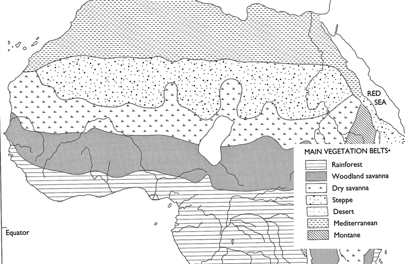
At left, see a map of estimated climate and vegetation for parts of Africa relevant to us from about 19,000-8,500 BCE; for conrast, at right, the same area from 8,500-6,500 BCE.7
While climatological estimations and datings for the region vary, archaeologists and physical anthropologists appear to agree that human populations physically resembling those of contemporary sub-Saharan Africans (labeled “Sudanese” according to broad features of physical type) lived south of the Sahara, limited to the zones labelled above left as “rainforest” and “savanna” (probably mostly occupying the latter), and then they moved more northward as foragers during the early Holocene period (following about 10,000 BCE), where greater diversity of resources were evolving with the increased rainfall regimes, including lakes, streams, and richer vegetation. Eventually they occupied most of the regions labelled above right “woodland”, “dry savanna”. and “steppe”. During the same time, distinctive populations formerly limited to the narrow coastal fringes of North Africa moved southward with an expanding “Mediterranean” climate and into the desert as well.8
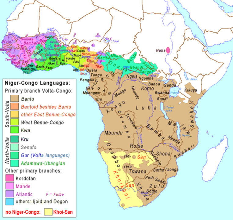

The historic distributions of major language groups who presumably occupied what is now the Savanna-Sahel-to-Sahara belt at this time are two, the “Niger-Congo” and the “Nilo-Saharan” language families, whose continental distributions are westward (at left, all of the colored areas except for extreme southwestern Africa)and eastward (at right, excluding the encompassing dark green area) respectively, though the maps alone are misleading if simply viewed as wholes in their raw forms.9
Linguists understand that each of these maps display overall distributions of very recent-historic times, that is as recorded mostly during the nineteenth and twentieth centuries), they do as wholes reflect ancient times; the older dimensions of location only begin appear when you consider the color-codings that distinguish various sub-groupings within the families. First, in the Niger-Congo map above left, note that the nearly the entire distribution of languages marked in brown color — the speakers of the Bantu languages — reflects a relatively recent invasion by one late sub-set of Niger-Congo speakers into central, east, and southern Africa. The older center of gravity of the Niger-Congo language group is limited to western Savanna-Sahelian zones; speakers of this family were in early times not located in the Congo or further east and south10 Should this latter suggestion hold, a tentative link between a very ancient language community (“Niger-Saharan-speakers”) and a general human physical type (“Sudanese”) would seem probable for the time-frame somewhere around 10,000 BCE.11 But these uncertainties need not detain us here: the picture we seek is anyway provisional, and will change in details with time.
At the level of time-depth where these two proto-languages were spoken, Archaeology tells us that the people scattered across Sahel-Sahara were, without exception, foragers, variably hunting and fishing, collecting grains and root crops (including types that would later become domesticated). Surprisingly in light of earlier conventional thinking, by 7500 BCE some ancestors of the Nilotic-speaking (Nilo-Saharan) peoples became cattle-keeping pastoralists, a practice that soon afterward spread fairly rapidly across the Sahara. (Further comment on this development will be made below.)

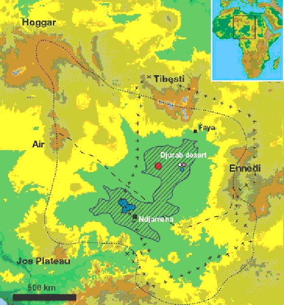
Roger Blench and Christopher Ehret, two linguists prominently engaged in this history12, largely agree that sometime between 9,000 and 8,000 BCE the early speakers of these groups were distributed roughly as I show on this map at left. The Afro-Asiatic speakers who moved from northern coastal areas into the now-enriched,no longer desert but “Mediterranean” landscapes of the northern Sahara were (in part anyway) ancestors of the Berbers (of whom the Sahara-dwelling Tuareg are a familiar group). The Nilo-Saharan speakers at this time occupied the dry savanna and steppe country (the “Sahel”) stretching from west of the Niger Bend eastward to locations far beyond then-massive Lake Mega-chad. See at right, for example, a map of the extent of this enormous Early Holocene Lake. Here, the boundary of the old lake is marked in hatching. Part of the Bodele Depression, this region is now the dustiest area on earth (its floor composed of fine-powdery remains of the plankton that once thrived in the waters of that lake. What remains of the lake recently is marked in blue.)
Both language and archaeological evidence point to an early spreading of Nilo-Saharan from lands considerably further east, aligned perhaps with what has been called an “Aqualithic” culture based to a considerable extent on fishing and other waterway pursuits.13 The Niger-Congo speakers were located from the upper reaches of the Senegal River on the west to what is now northwestern Nigeria on the east. 14 Ehret infers that Niger-Congo language included terms indicating intensive collection of wild guinea yams (Dioscorea spp), a major advance in the technology of food-collection.15
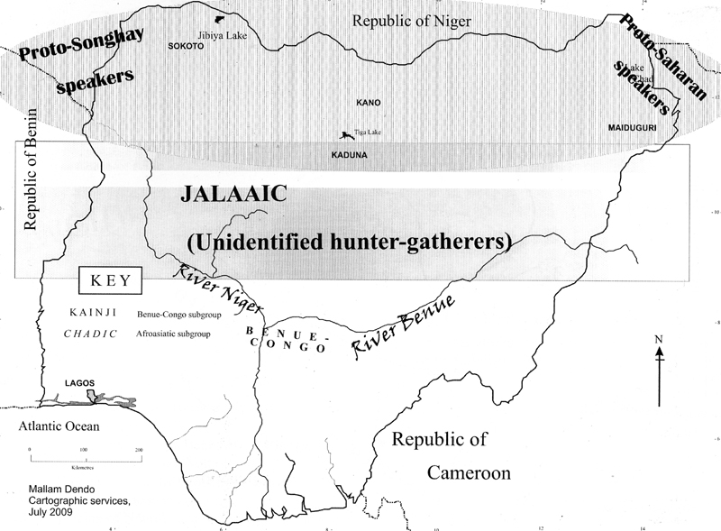
At right I present a map of the region which is now Nigeria, adapted from Blench 201016, showing a distribution of Nilo-Saharan speakers running across the northern portion of the map (with two presumed ancestral speech subdivisions of Nilo-Saharan, arising on the west and east). Here he infers that speakers of the Chadic group of Afro-Asiatic languages, who today occupy much of the northern zones in-between the Songhay and Saharan languages, were not present in this area at this earlier time. (We will discuss the matter further below.) South of this Nilo-Saharn group he shows unidentified hunter-gatherers who presumably lived in the wooded savannas and rainforest to the south, including (tentatively) one named group (Jalaaic, an apparent language-isolate still located in the area shown here).
The point of this representation is to emphasize that in this region foraging peoples of whom little is known were present at this very early time; these areas may have included, for example, populations now called “pygmies”, their ancient languages now unknown. But it also seems likely that this “unidentified” area may likely have included speakers of a very early branch of Niger-Congo, called “Gur-Adamawa”, whose proto-language posseses no known cognates indicating cultivation, suggesting they were groups who were likely bow-and-arrow hunters as well as opportunistic foragers, and who may or may not have extended into this area at the time in question17. (More on them below.)
It makes sense to emphasize cultural anthropologist Igor Kopytoff’s view that, during this early period of relatively humid climate (prior to the massive and progressive dessication that occurs later on), most populations ancestral to those presently occupying sub-Saharan Africa were concentrated “in the now-barren but then fertile Saharan-Sahelian band that spans the continent from east to west”. He suggests that this is the area where “‘incubation’ of the defining ancestral pan-African culture patterns took place, often under frontier conditions….”
These notions — of “defining ancestral pan-African culture patterns”, and of “frontier” conditions, are important, and we will focus on the “frontier” quality of sub-Saharan African settlement patterns later (and mainly in other chapters). Kopytoff goes on to observe that
“From this ancestral ‘hearth’ of African culture, after the onset of dessication of the Saharan-Sahelian belt… a population tide crept slowly southward, out of the expanding Saharan desert and into the savannas, even while the savannas themselves expanded southward at the expense of the equatorial forest.”18
This implies that geographical centers of language speakers probably began somewhat north of their current distributions as shown on the current linguistic maps. Climatologists now affirm that a major drying of the land occurred in Africa around 3,900 BCE,19 a reversal of the previous, Holocene-defining wetness, which drastically altered living conditions, forcing people to abandon drier areas and begin moving southward into wetter ones (including Rain Forest).
According to Christopher Ehret, the earliest subdivisions of the Niger-Congo language contain terms for cultivation, apparently associated with the Guinea Yam (Dioscorea spp.) and indicating a spread of peoples “across the woodland savannahs of West Africa, the natural environment of guinea yams”20
Ehret continues:
“Then at around 5000-4000 B.C., at a period of shift to somewhat drier climate, the proto-Benue-Kwa descendants of the proto-Volta-Congo people expanded southward into the rainforest belt of West Africa. The glottochronological dating of this spread of languages places it in about the sixth millennium (Armstrong 1964), and that dating correlates exceedingly well with an expansion into the rainforest, known from the archaeological record, of peoples who made polished stone axes (Shaw 1978-9). Yams and oil palms require sunlight to grow, and stone axes would have been the essential tools of the incoming Benue-Kwa cultivators for converting forest into clearings.”
Although Ehret thinks that this major cultural event of plant domestication may have begun between 8,000 and 6,000 BCE, archaeologists tend to see it coming very much later21. It’s important to remember that purely linguistic time estimates are usually no more than “educated guesses” when used without other evidence. Ehret relies for some of his dates on glottochronology , a method of linguistic time- estimation whose assumptions are controversial and no longer generally accepted by linguists. On the other hand, the timeline for the aridification just outlined is fairly well established, and its cultural implications were undoubtedly profound.
2. The Major Subdivisions of Niger-Congo
Niger-Congo is in fact the largest language phylum in the world, with some 1,436 distinct languages grouped into an array of branching trees marking off sequential nesting subdivisions as speech communities gradually diverged from one another in space and over time22.

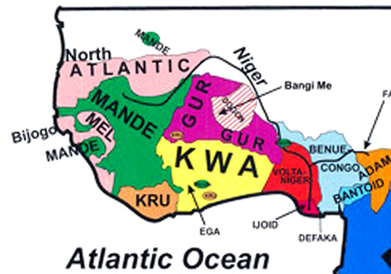
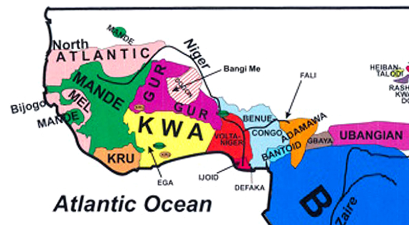
Here we limit our focus to the parts of west to central Africa that are most relevant for Igbo ancestry. To begin, the pink and purple colors denote speakers of the Mande and Atlantic major branches, which we will consider very briefly first. (Note also the dark-labeled “Dogon” south of the great Niger bend, and the “Idjo” marker at the base of the Niger Delta. These too represent significant major branches.)
Below, a current model of the oldest series of divisions in the Niger-Congo Language group, in descending sequence of separations.23.
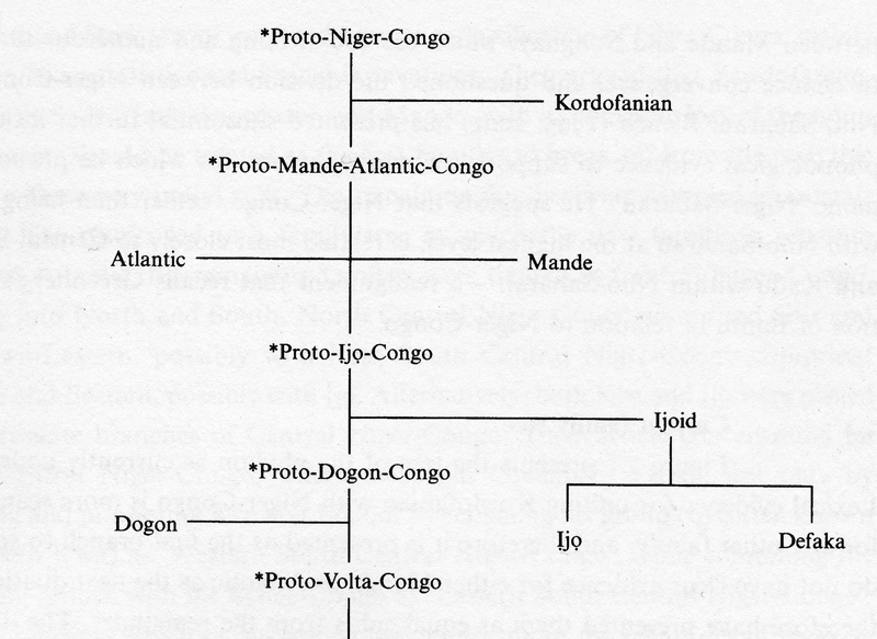
As our authorities indicate, this diagram represents the historical base of the tree of the phylum “as currently understood”24. “Kordofanian”, a language group located in the Nuba Hills of southern Sudan, is represented in the color-coded map above by the red patch at far right marked “Nuba”; Proto-Niger-Congo consists of all the rest, a coat of many colors. Kordofanian is so remotely related to the entire set of Niger-Congo (and so poorly known in detail) that we set it aside here.
Consulting the chart further, you will see that our authorities pose a second, tripartite separation occurring among the Atlantic group, the Mande group, and a third entity that comprises all the rest of the Niger-Congo speakers. Since current knowledge cannot distinguish the splitting points of these three, they are shown on the diagram as dividing into separate units at roughly the same time.25 The Mande group roughly corresponds to Murdock’s “Nuclear Mande”, regarded as a major cultural force in the history of the region26. We will largely set aside both Mande and Atlantic groups in our discussions here, though they both become historically important at later historical stages as creators of large-scale political communities involved in widespread trade affecting the Igbo area. (Note, in passing, the distinctive situation of one sub-group of the “Atlantic” languages shown on the color-coded map, that of the Fulfulde or Fulbe speakers, the Fulani, marked “F”. on the map For more on the topic of this group, see this link: https://amightytree.org/fulani-language-and-history ).
Now note that the splitting diagram above shows a separation of the family Ijoid as the next time break in the group: Ijoid languages, marked in blue on the color-coded map, are sharply distinct from all other Niger-Congo groups27, though little differentiated within the family itself. It seems obvious to infer that its speakers, historically found only in the Niger Delta rain forest area (where their distribution is in written-historic times entirely near the coast) moved there earlier than the later invasions of those who would become the language groups that include Igbo-, Edo-, and Yoruba-speakers, but the timing of their movement remains a mystery.28 I will discuss them later below.
The final split shown on the chart presented above is that separating the speakers of Dogon languages from other members of the remaining group. Dogon is a coherent cluster of languages that Blench estimates have been differentiating for some 3-4000 years within a concentrated area around the Bandiagara escarpment in the central plateau of Mali south of the Niger Bend. This language group is quite distinct from all other Niger-Congo languages, and probably long isolated in their area. 29
This summary brings us to the final grouping shown on the diagram above, that labelled “*Proto-Volta-Congo.”30
3. The Volta-Congo Languages
Unfortunately, we must deal here with labels that are to some extent contested by differing linguists and these variations become confusing (not to mention that they continue to change over time). I have decided to emphasize one set of the terminologies encountered, in order to simplify the discussion.
The separations of these two major groups into West and East, with their further subdivisions, probably relate in part to the southward movements associated with the major West African dessication following 4,000 BCE that we previously outlined, and they have come to correlate with differences in geography.
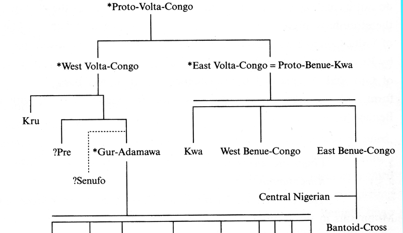
3.1. West Volta-Congo:

Here perhaps placing The West Volta-Congo diagram (at left) along with another of Roger Blench’s distribution maps, at right,will be helpful.
The significant contrast here is between the reconstructed complex of “Gur-Adamawa” on the one hand and Kru on the other. Note that, as shown on the map at right, Gur, a prime member of the Gur-Adamawa group, has no coastal or large-riverine distributions, while in contrast its West Volta-Congo sister group Kru shows evidence of having moved to the Atlantic coast in the fairly distant past. Gur in this map is colored in magenta, Kru in tan. The Kru languages have many subgroups, all located near the coast, and have been prominent there for a considerable time.31 In contrast to its isolated relative further north, the connection of Kru-speakers to the sea opened them to a wide range of transformative influences.
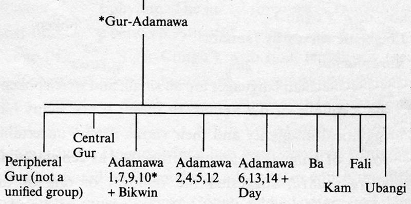
Note that the Gur-Adamawa sub-group (A sufficiently coherent unit that some elements of its proto-language haxe been reconstructed) is grouped togather here marked with a double line by our authorities32, indicating that the entire group appears to comprise (under the rubric Gur-Adamawa) an old “dialect continuum”, a situation in which dialects spoken across some geographical area differ only slightly between neighboring areas, yet differences accumulate such that speakers from opposite ends of the continuum are no longer mutually intelligible33. A relationship of this type is the more striking by virtue of the fact that the major divisions of the two language groups — Gur and Adamawa — are now separated from one another by a geographical gap of around a thousand miles. Our authorities comment that these “…languages are presumed to have once spread continuously across much of the savannah of West African before… Gur and Adamawa-Ubangi were broken apart by the expansion and/or incursion of Chadic and Benue-Congo.”34 We consider this in more detail further below.
3.2. East Volta Congo (= “Proto-Benue-Kwa”)
Now note that the group marked “Kwa” (in Yellow) on the color-coded map here, and the two groups further east marked “Volta-Niger” and “Benue-Congo” (but note: they are labelled “West Benue-Congo” and “East Benue-Congo” on the Volta-Congo diagram and we will use these latter terms in what follows) have separated and isolated Gur from both of its closest linguistic kindred (Kru to its southwest and Adamawa and Ubangian toward the east). This points to later expansions by the three groups, who as the Volta-Congo diagram further above shows, represent descendants of the sister group to “West Volta-Congo”, named there “East Volta-Congo” (or “Proto-Benue-Kwa”).
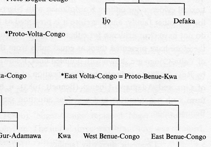
It is of interest, however, that the proto-language which contains all three sub-groups of this unit -Volta is construed by our authorities (at right in the branch diagram here) to comprise another dialect-continuum (what they call “Proto-Benue-Kwa”).
This implies that Proto-Benue-Kwa speakers once shared a very coherent, continuous area of distribution.
Returning now to Blench and Dendo’s study of 2010, viewing Map 3:
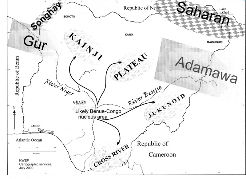
Here Blench & Dendo provide a primary resolution to two questions: first, how Gur and Adamawa, once a “dialect continuum” of settlement from east to west across what is now Northern Nigeria, came to be separated from one another by about a thousand miles, and secondly, how the (“East”-)Benue-Congo languages came to he distributed in the scattered locations they now occupy. On the basis of the logic of “least movements”, the point of geographic dispersion would be a “Benue-Congo nucleus area”, as the authors suggest above, one located near the confluence of the Niger and Benue Rivers. (But note that this dispersal map diagrams East-Benue-Congo only. More on this point below.)
Below I present the linguistic-genealogical model as Blench drew it in 2004, starting with “*Proto-Benue-Congo”. Here consider mainly the sub-divisions of what we are (with Blench) calling “East Benue-Congo“: Central Nigerian, Ukaan (?), and Bantoid-Cross. The groups he displays on his arrow-motion map above — Kainji, Plateau, and Jukunoid — are here below grouped under “Central Nigerian”. In the map above, he does not include an arrow for “Bantoid” migration at this putative time level, but such an indicator would run out from somewhere near the northern portion labeled “Cross River” area, Bantoid being a subdivision of that group in the diagram (implying that its movements occurred later than those establishing the Cross River group as a whole).
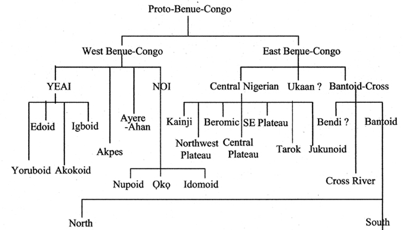
This diagram as shown stops at the two divisions of “Bantoid”, a group labeled “North” that includes a number of languages distributed in the highlands along what is now the Nigerian-Cameroon border, and a second, “South”, which includes a vast array of languages, some located in the same general region of Nigeria-Cameroon borderlands, but others (including the so-called “Narrow Bantu”) now spread over entire regions of Central, Eastern, and Southern Africa. These we omit from direct consideration (but see this link for a Glotto Map showing the distribution of Narrow Bantu: http://glottolog.org/resource/languoid/id/narr1281.)
4. Expansion-zone Contexts
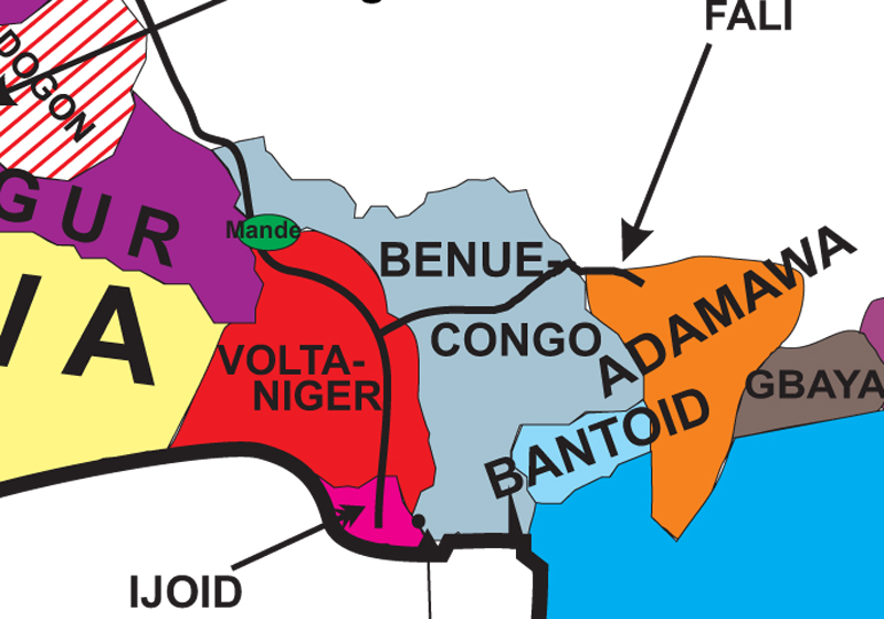
The map below now directs our focus to those Niger-Congo languages directly related to these processes of expansion in the area of our central focus (begun with the dessication of Sahara and Sahel as dated by climatologists around 3,900-3,300 BCE). This Wikipedia map labels these as “Volta-Niger Languages”, with two major sub-groups,”North Volta languages” and “South Volta languages”(West Benue-Congo and East Benue-Congo being subdivisions of the latter).35

In reference to what has previously been said: the two aqua-colored language groups, here on mid-map marked as “Baa-tonum” on the west and “Mumuye” and “Gbaya” on the east, denote the “Gur-Adamawa” group, now separated by a complex array of languages and language groups.36
The yellow language markers denote the “East Benue-Congo” groups discussed above in connection with Blench’s suggested expansion from their “Benue-Congo Nucleus Area” shown in his map above , with Bantoid subdivisions thereof marked in brown. The languages marked in green are the ones that will be focal for us: West Benue-Congo.
Before we proceed with these, however, it’s useful here to call attention to two major if (for us at this point) “peripheral” groups that affect this history.
4.1 Chadic Speakers
The Hausa language is the largest member of one of the four major subgroups of the Chadic group of languages (shown on this map in a pale tan color), encompassing many small groups of speakers located from central Chad in the east to the central Nigerian plateau in the west. Chadic in turn is one of the six major divisions of Afro-Asiatic (also including Berber, Egyptian, Semitic, Cushitic, and Omotic)37, which suggests that its most ancient affiliations lie in the north-and-northeasterly portions of Africa (among wild-grass-collecting peoples living there perhaps before 13,000 B.C.E.)38 Chadic speakers have resided in the region of northeastern Nigeria indicated on this map for a long time, and linguists do not currently agree whether they likely moved in from the north or from the east (the two major directions where their sister languages are located)39.
Proto-Chadic speakers had words for cultivation, sorghum, sheep and goats40. The Hausa kingdoms, well-known historically by the 15th century C.E, arose out of the mists of time from this long-resident Chadic-speaker matrix, and Hausa then spread far and wide as a trade language.41 These Chadic groups are important to the deep history of our region, but how their distribution relative to the languages labelled “Volta” on the color map just above came about remains mysterious.
4.2. Nilo-Saharan Speakers
The Hausa kingdoms emerged, in turn (according to ancient historical accounts), from emigrants who left their royal positions in the Kanuri-speaking state of Bornu located west of Lake Chad. Kanuri (shown in the map above in very pale green color at far upper right, bordering Lake Chad) is a southwestward extension of “Nilo-Saharan“, a very diverse and dispersed category whose oldest divisions are unclear. Derek Nurse42 suggests an ancient dispersal for Nilo-Saharan from the vicinity of Lake Chad, but a center of gravity between the greater Nile basin and the central Sahara desert has also been suggested. Kanuri is definitely part of a Kanuri-Kanembu branch that is in turn related to Tebu, a group of languages belonging to camel-keeping people who have long occupied the Tibesti Mountains of northern Chad and southern Libya, and who definitely mediated trans-Saharan trade from and to the North African coast during the early years C.E. At a much earlier time, Nilo-Saharan speakers independently developed cattle-keeping pastoralism in the Nabta Playa region of Southwestern Egypt, with a firmly-grounded calendar date of 9000-7400 B.C.E43, and Wendorf and Schild (2000) suggest that the people who occupied the subsequent Late Neolithic “Megalithic” sites at this location (with architectonic features indicating high degrees of central organization, and dating from 6100-5600 B.C.E.) may have been instrumental in the formation of the later great Kingdoms of Ancient Egypt, which they much pre-date.
This kind of firm and very early dating definitely throws a startling new light on African History. Some of the time-frames earlier presented by Murdock have definitely moved deeper as a result of such work. Ehret (2002:61-75) sees some of these Nilo-Saharan-speakers not only as independent inventors of Sudanic agriculture but also as early carriers of what he calls an “Aquatic Tradition” of food-production, spreading westward along the Sudan from (an estimated) 8800-5500 B.C.E.44
Extended discussion of representatives of these two groups — the West Chadic group of northeastern Nigeria or the Nilo-Saharan languages to which Kanuri belongs –would lead us too far afield here, but as historic agents of trans-Saharan and trans-Sahelian trade at various time-levels in the past they have importance to our story. Their presence in the historical field of our interest is definitely old, and their agents carried important aspects of culture that impinged upon ancestors of Igbo-speaking people, so we must keep them in mind for later discussion. Specifically: early 20th-century speculations about links between our area and ancient Egypt, long categorically dismissed by most anthropologists, should be given more open consideration in light of the archaeology coming out of the Nabta Playa. See for example Sutton’s 2001 paper on “Igbo-Ukwu and the Nile”45
5. Expansion Contexts, Continued

Returning to the language groups marked in the Wikipedia color map as “South Volta-languages” (as at right here), these divide into three main sets, but we are concerned here mainly with two, setting aside the Kwa group and turning to our primary interest, the “West-Benue-Congo” group (whose distribution is limited to the southwestern portion of the “Volta-Niger” map shown above).
Now recall that among the depicted groups of “East Benue-Congo” languages, two of these sets currently have geographical distributions that are split apart.

Toward the northwest is the group marked in yellow, which Greenberg originally labeled “Platoid” to suggest its center of gravity on the Nigerian Plateau, but which is now called “Central Nigerian“. Toward the southeast is the group marked in shades of brown (excluding however the very pale faintly beige-ish color mostly toward the upper portion of the map, which represents Chadic speakers — Hausa and others). This brown-colored grouping is here called “Bantoid-CrossRiver”, and includes a considerable array of languages, of which the entirety of Bantu is but one subdivision.
“Central Nigerian” (yellow), as shown in the diagram below46 present a series running roughly from west to east:
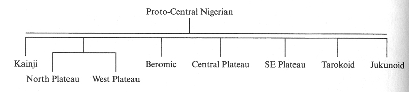
In presenting the group as linked by a double bar (here above), again they propose that the entire group forms an old “dialect continuum” in the same sense previously outlined for Gur-Adamawa. That members of such an old continuum among these groups are now separated (as we see in the yellow blotches scattered across the map shown above) suggests that the geographic separations we see on the map occurred mainly by way of expansions or intrusions of distinctive speaker-groups from without, here due to groups of West Benue-Congo (as well as Chadic groups, and of course the purple-colored Fulani groups, though these latter are known to have entered these areas very recently in historical terms — mainly 19th century to present, and are not relevant for this part of our history).
The groups of East Benue-Congo languages that are most closely linked with Bantu are another case of this kind. the Bantoid languages for example (shown in shades of brown), have a cluster of their oldest relatives on the Nigerian plateau (members of the larger group now labeled “Bantoid”47, or “Bantoid-CrossRiver”) indicating that Bantu speakers spread out from that area after their ancestors separated from those other tongues, and subsequently spread largely southward into rain forest, then out into the vast regions of central, eastern, and southern Africa that descendant Bantu-speakers now occupy. George Peter Murdock48 first spelled out the historical implications of Greenberg’s then-new classification of these Bantu-related languages:
“The Bantu languages as a group, despite their wide distribution, constitute but one of seven branches [of the Bantoid group, RNH]…. The other six branches… are confined to a very small area near the Cameroon-Nigerian border. On linguistic grounds it is impossible that the Bantu can have come from anywhere else.”
Based partly on glottochronology and partly on other cultural data, Murdock estimated the dispersion of Banu out of that original homeland into the tropical forest to have occurred approximately 2,000 years ago49 This inference is now regarded as much too recent an estimate. Some, like Ehret50, think it began several thousand years earlier. Vansina 51, on much firmer linguistic-technological grounds, implies a movement that began by perhaps 700 BCE.
6. “West-Benue-Congo” Languages
The groups that expanded to break apart the previously dispersed East Benue-Congo groups in the central part of Nigeria were predominantly those now distinguished as the “West-Benue-Congo” group of languages (though on the map at left, they are called “Volta-Niger”.. This means (following the historical inferences about cultivation outlined above) that this speech-community moved from the Nigerian plateau south toward and into the rain forest, and that the speakers of their proto-languages began differentiating into their separate but overall contiguous locations, from their center of historical gravity lying somewhere in the area surrounding the confluence of the Niger and Benue Rivers.
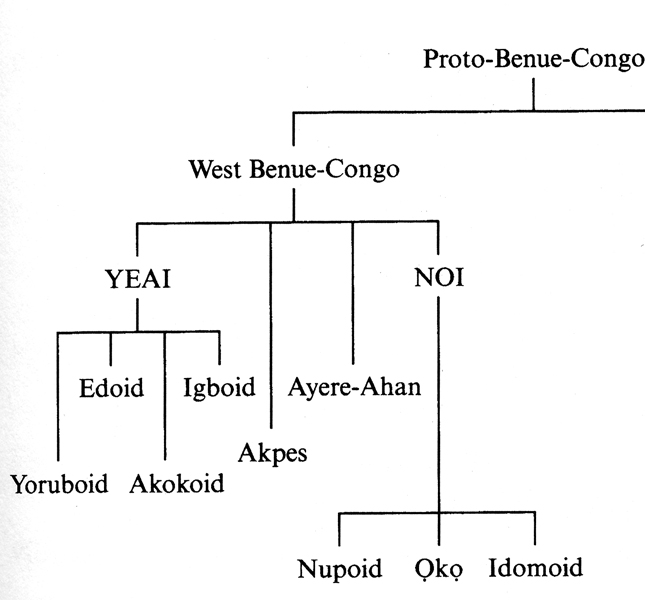
At left, we now focus on this group of languages, following the genealogical diagram of our authorities.52. Within the major group are four main divisions in terms of linguistic difference: YEAI, Akpes, Ayere-Ahan, and NOI. Of these, the middle two in the diagram — Akpes and Ayeere-Ahan, are (in recent times) language islands contained within a surrounding Yoruba-speaking “sea”. The same applies to Akokoid (within the YEAI group). This suggests that these groups moved into the forest prior to the Yoruboid group, who subsequently expanded further, in several directions, eventually engulfing them.
Now Below, a map highlighting this historically very prominent group, shown in shades of green (setting aside the Fon, who are now classed as a “Kwa” group and thought to have spread in concert further west):
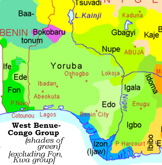
Since the Edoid (in very pale green) and Igboid groups show a solid geographical distribution running into the forest, it makes sense to infer that these two groups moved into that domain first, more or less paralleling each other. The Yoruboid expansion, which includes both Yoruba and Igala languages and which came to border (and to some extent enfold) both the Edo and Igbo groups, poses special questions in light of its very widespread distribution. Robin Horton (1979) presented a diagram interpreting the expansion of its major divisions, utilizing the comparative linguistics study of Akinkugbe (1978) and Obayemi’s (1976) earlier suggestions.53 In the map below, I show a rough version of that diagram, together with suggested movements for the other main divisions of West-Benue-Congo (setting aside the small encapsulated groups just discussed).
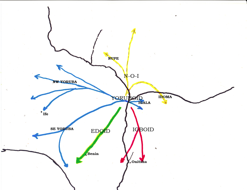
The last branch of “West-Benue-Congo”, labelled “NOI” on the diagram (for Nupe-Oko-Idoma), shows a similar center of gravity around the Confluence, Nupe with a movement to the north, Idoma to the southeast, and Oko perhaps no movement at all (it is a small group located southwest of the Confluence, now encapsulated by Yoruba and Nupe speakers). The arrows do not imply definite points of origin: we may presume, for example, that the origin of Igboid lay somewhere near the Benue-Niger confluence, but should not assume any detailed origin point, and the same applies to the other major divisions of the stock.
One might question whether a “West-Benue-Congo” dispersion might be better viewed as occurring from a location further west than the one suggested above by Blench for “East-Benue-Congo”, but our authorities seem to be adamant in regarding this as the linguistic home for both the East and the West branch. Williamson in her “Benue-Congo Overview” of 1989 (p. 272) identified the Niger-Benue confluence as the focal point for the entire Benue-Congo homeland (both West and East), while Blench (2004) strongly emphasizes
“…the importance of Central Nigeria (probably the Niger-Benue Confluence) as a centre of radiation for the branches of Benue-Congo. The various branches of Benue-Congo can be seen to radiate out from it ‘like the spokes of a wheel’ in Robert Armstrong’s felicitous phrase. This in turn suggests the possibility of a riverine arrival in the region and waterways as a channel for further dispersal.”
So the upshot of all these distributions and inferred movements is a focus on the Niger-Benue confluence as a center, both of gravity and of expulsion, for all of these language groups . Something connecting this geography with the culture history of the human populations involved with the area has produced potent dynamic sequences here. In other words, as we approach a time when early “Igbo” was spoken, we also become deeply involved with the meanings of what the Igbo themselves have long called “Olu“. One potential key to this is the fact that the speakers of Proto-West-Benue-Congo (or Volta-Niger) languages share ancient vocabulary words specifically relating to elaborate patterns of trade, e.g. a term denoting “profit” (Blench & Dendo 2004:69). This might well point to a shared location at the central hub of a (ca. ) 2000-mile waterway that has surely stimulated east-west communication across the continent for a very long time, and in which these ancestral speakers participated.
- And my own ethnohistorical study of precolonial Onitsha used this kind of work in a general way, Henderson 1972: 38-43. [↩]
- Greenberg 1949 etal. [↩]
- Wrigley 1962 provided a cogent early assessment of the value of linguistic evidence for interpreting aspects of African history. For some more recent efforts to connect archaeological and linguistic evidence for West Africa, see for example MacDonald 1998 and other works in Allsworth-Jones, ed. 2010. We will give a number of examples in the text below. [↩]
- Numerous variant terms have been suggested, but issues regarding the definition and even the “reality” statuses of some of these entities and their putative subdivisions need not concern us here. Enough acceptance of these groupings is present that we may proceed with caution. [↩]
- 1997:389 [↩]
- See, for example, Ehret 2000:294. [↩]
- Both maps are adapted from Ehret 2002:34, 60. [↩]
- MacDonald 1997:45-46. [↩]
- Thanks here to Wikipedia, these images were drawn from their entries on Niger-Congo and Nilo-Saharan. as of 2012. [↩]
- Except for Kordofanian, a case of even more remote relationship that we will not address here at all.). Indeed, the placing of “-Congo” as part of this label (and of all sub-groups so labeled within the group) marks the fact that the group so named contains among its sub-groups the linguistic ancestors of the Bantu.
Regarding the Nilo-Saharan map above right, note that the distributions shown running to the southeastward from the Sudan region are also relatively recent; the old center of gravity of this group appears also to be Savanna-Sahelian-Saharan. We will consider these points in more detail momentarily.
I here note that, at their oldest levels of reconstruction, Niger-Congo is generally accepted while the unity of Nilo-Saharan remains somewhat in question. Some recent expert opinion regards these two great families as themselves related, forming an even older proto-language grouping of “Niger-Saharan”. ((For example, see Blench 1995. [↩]
- At lower levels of language grouping, linkages of genetic ancestry and language become much less likely, indeed some confounding of these two is more or less the rule. [↩]
- And who disagree on many points of reconstruction, for example, see Ehret and Blench . [↩]
- Sutton 1974. [↩]
- Blench 2010: , cf. Ehret 2000: [↩]
- For more details, see Ehret pp. 44-51. Murdock 1959: 64-70 attributed the earliest actual agriculture among this group to what he called “the Nuclear Mande”, a major sub-group located somewhat toward the western portion on the Niger-Congo map, basing his inferences largely on known distributions of native forms of domesticated plants. [↩]
- With thanks to Mallam Dendo Cartographic Services, the map’s designer. This is Map 2, p.163. [↩]
- Blench 2010:163-4. [↩]
- Kopytoff 1987:9-10. [↩]
- Called the “5.9 Kiloyear event”, i.e. 5,900 BP, see Claussen et al, 1999. [↩]
- Ehret 2000:294. [↩]
- Cf. MacDonald 1997: [↩]
- Williamson & Blench 2000:11. [↩]
- In most of the language-history diagrams used here, I rely greatly on the work of Williamson and Blench 2000), and will refer to their work as “our authorities”. This first tree is from p. 18 of that essay. For a later, “rough-draft” essay focusing on a subset group, see Blench & Dendo 2004, and also Blench 2010 and others. [↩]
- Williamson & Blench 2000: 17 [↩]
- Williamson and Blench 2000:17-22. [↩]
- 1959:64-77. [↩]
- Williamson & Blench 2000:22. [↩]
- See Blench 2010:166-7, who suggests the Ijo may have represented an upper-Niger mobile fishing people who moved relatively late into this location. [↩]
- Their art and culture have become iconic in Western literature as an example of pre-colonial, pre-state sub-Saharan African cultures and societies. See this link to Wikipedia for a useful introduction: http://en.wikipedia.org/wiki/Dogon_people. [↩]
- Williamson & Blench 2000:18. [↩]
- Andrew Dalby (2000) noted the historical importance of this group: “Kru and associated languages were among the first to be encountered by European voyagers on what was then known as the Pepper Coast, a center of the production and export of Guinea and melegueta pepper; a once staple African seaborne trade”. [↩]
- Williamson & Blench 2000:18 [↩]
- Bloomfield 1935 p. 51 [↩]
- Wiliiamson & Blench 2000 p. 24. [↩]
- The group shown in purple and marked “Bokobaru” represent Mande-speakers who have intruded from further west. [↩]
- Portions of the Adamawa-Ubangi sub-group, not demarcated here, underwent a very substantial expansion eastward, out of an inferred homeland in the Adamawa highlands of northeastern Nigeria and Northern Cameroon (where the Adamawa subgroup’s distribution centers). The Ubangi division of this language group spreads east from that area all the way into what is now Sudan, and into northern portions of the Congo Basin, and some of its languages have eventually become regional lingua francae in those zones. [↩]
- Hayward 2000:74-98 [↩]
- Ehret 2000:291. [↩]
- [↩]
- op.cit.:292 [↩]
- According to Greenberg, Hausa has become in recent times “perhaps the most widely spoken (language) in Negro Africa.” Cited in Ifemesia 1965:91 [↩]
- 1997:37. [↩]
- Wendorf & Schild 1998, Ehret 2000: 285 [↩]
- MacDonald (1997:42-4) regards (from an archaeological perspective) this “Aquatic” conception as an illusion, but the vast east-west corridor of waterways that existed during this time must have had great significance for human adaptations there (as did the more scattered ones existing later. [↩]
- Sutton 2001. [↩]
- Williamson and Blench 2000, p.30 [↩]
- Wiliiamson & Blench 2000:35. [↩]
- 1959: p. 271 [↩]
- ibid., p. 273). [↩]
- 2002:113-116 [↩]
- 2006:354-56 [↩]
- Note that Blench 2004 in his proposed reclassification retains this structure for the group. [↩]
- Akinkugbe identified 5 Yoruba dialects, NE, NW, SW, C, and SE, the major division running between the first four and SE, while the latter is close to Itsekiri (which she regarded as a separate language), here represented by the southernmost blue arrow on the diagram below. Yoruba-Itsekiri as a whole is most closely related to Igala, hence the designation “Yoruboid” for all of this set. (Horton 1979:73). [↩]