Key to the Image above: Eocene “Nanka Sands” meet Holocene Alluvium (Uplands vs. Floodplains)
[Note: Click on any image you may want to enlarge.]
The Geography of Cultural Contrasts: Rivers and Uplands

In its cultural history, the ancestral communities out of which the current city of Onitsha grew were primarily (but not exclusively) Igbo-speaking peoples (whose partial boundaries prior to the beginning of Colonial times are marked in the map at left as “Ibo”), 1 but their “cultural identities” were complex by virtue of a unique geo-historical position: those who call themselves Onitsha people (Ndi-Onicha) claimed partial origin from the Igala kingdom to the north, asserted a “sibling kingship” with the Aboh kingdom in the Olu lands to the south, identified their historical origins as lying far to the west beyond Agbor in the Edo-speaking kingdom of Benin, yet they also acknowledged a deep-rooted cultural identity link with the much more ancient Nri kingdom located to their east. (One proverb exaggerated their condition by saying, “Onitsha people cannnot swim” — a metaphoric reference to their distinctive proto-historical situation: living “on the River” but partially divorced from it.)
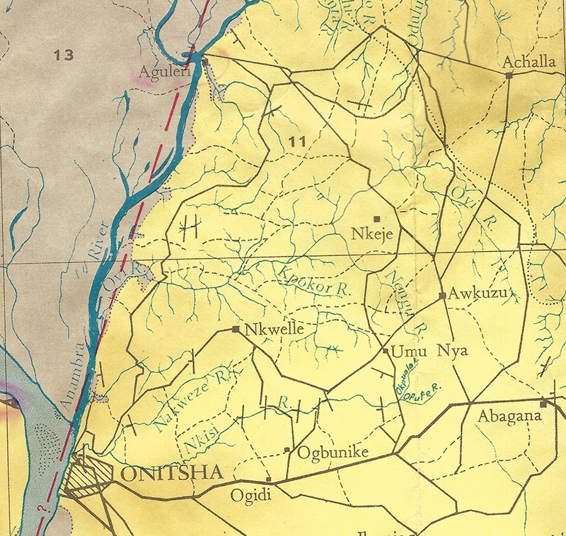
Below left, a map focusing on the Asaba-Onitsha Uplands, showing how these two high terrains are bisected by the River Niger with its associated floodplains 2. These uplands (shown in plain white in the image below),
which extend as hills from this intersection running both east and west from Orummili (The Niger River, or “Plenitude of Waters”, as Onitsha people call it), have long served as places for stable human settlement (in sharp contrast to the floodplains, which historically have posed much greater obstacles to long-term occupation because of the massive seasonal flooding of the”Plenitude of Waters”).
Indigenous peoples of the region in former times identified people of the uplands west of the River as “Ndi-Enu-Ani” (in Igbo, transl. “those of the Highlands”. Today, these same people also refer to themselves as Ndi-Ani-oma. “those of good lands”). Ndi-Onicha, ancient owners of the land now called Onitsha, emphasize their ancestral kinship connections with many of these Enu-Ani towns named on the map (some of which also possess the historical name “Onicha“) and say they traveled eastward across this western-uplands region in a time of great military disturbances caused by the enslaving transgressions of the mighty Empire of Benin (their original home is designated as in the far-western neighborhood of this great old center of military power), crossing the River sometime after the early 16th Century, where they settled first in the lower banks and then gained control of that small but geographically uplifted portion of the east bank that eventually took their name. 3
The Western Igbo-speakers living west of the Niger call this migrant community Onicha-mmili (“Onitsha-by-the-water “, we might say). In contrast to the regions of historically moderate-density populations that extend westward beyond the city of Asaba, Onicha-mmili confronts an eastern upland containing some of the heaviest rural population densities in all of Africa (as shown in the image below) 4.

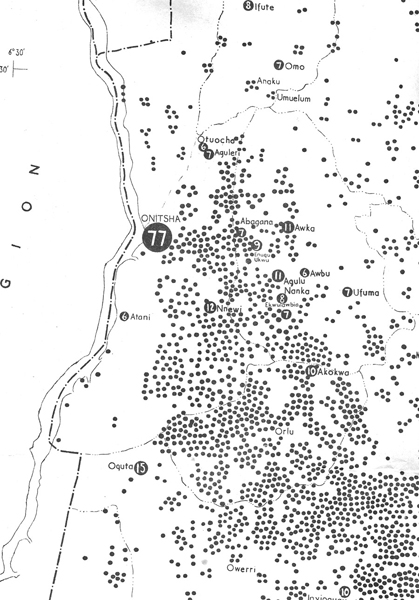
And a very high proportion of the population of the 20th-century Onitsha town as it had become at the time of the Federal Census taken in 1953 (shown as 77,000 in the large black circle at right) was composed of recent immigrants from that eastern upland, who Ndi-Onicha called “Ndi-Igbo” in contrast to themselves (with a few exceptions, to be further discussed below).
These maps show the demographic basis of Onitsha’s position as a multidimensional central place. In geographical terms, As a center of trade, Onitsha by the mid-twentieth century possessed a potential “extra-urban service area” of incomparable size for this part of Africa. In addition, this densely-populated hinterland was a place of historical “food deficit”, with considerable soil deterioration, forcing many of its people to seek sustenance by other means, substantially by trade, but also by producing an oil greatly in demand in Western Europe at the time, that of the palm tree (Elaeis guineensis), which has long been numerous in these lands. By 1953, the Onitsha urban complex dominated business in this region (and was influential throughout Nigeria and beyond), with the nearby towns of Nnewi and Awka serving as important secondary centers. In terms of human capital, the Ndi-Igbo themselves have provided a tremendous social productivity, celebrated for example by one of their great ethnographers for their energetic “receptivity to change” 5.
Looking further backward historically for a moment: prior to European invasions beginning in the 1850s, the north-south corridor of the river, flanked by extensive forested floodplains on both sides except at the intersecting uplands location, fostered a complex and massive system of trade (prior to European 16th-century contact, it prominently trafficked in slaves, after the mid-19th century; in palm oil).

Looking further backward historically for a moment: prior to European invasions beginning in the 1850s, the north-south corridor of the river, flanked by extensive forested floodplains on both sides except at the intersecting uplands location, fostered a complex and massive system of trade (prior to European 16th-century contact, it prominently trafficked in slaves, after the mid-19th century; in palm oil).
This pre-european trade was dominated by the Igala Kingdom centered at Idah in the north and the Aboh Kingdom in the south, each linked to a number of trading communities located along the river as illustrated in the map at left. 6
Patterns of human communication were geographically fore-ordained by this bifurcating space of uplands and lowlands. In historical-cultural terms, some of the Igbo-speaking people of the area came characterize themselves with a formal contrast of Igbo-na-olu.
The meanings of this conceptual pair are complex and variable, but broadly speaking, Ndi-Igbo (“Igbo-people”) referred (in proto-historic times) to populations occupying the upland bush east of the Niger River, while Ndi-Olu (“people of the floodplains”) referred to those occupying the riverain lowlands along or near the Niger River 7.
Ndi-olu may also be paired in opposition to Ndi-EnuAni, or to Ndi-Onicha. And as we shall see, Ndi-Onicha sometimes themselves divide their internal memberships using these categories. These precolonial contrasts of ethnic identification were not primarily linguistic (since, for example, in some perspectives Ndi-Olu included Igala– as well as Igbo-speakers), but were rather primarily geographic-cultural, indicating differing life-styles predicated on location (upland bush versus waterways) but also affirming that distinctive relationships had developed between contrasting sets. 8
For our introductory purposes here, it is perhaps enough to observe (regarding Ndi-Onicha in their historical dimension) that the ancient founders of Onicha-mmili have definitely been remembered by their descendants as migrants of an heroic kind. Salman Rushdie, writing of his own late twentieth-century experience as an individual forced into involuntary, surreptitious acts of migration after being sentenced to death by an Islamic fatwa declared over the internet in 1989, made this very trenchant observation:: 9
The act of migration puts into crisis everything about the migrating individual or group, everything about identity and selfhood and culture and belief.”
This aspect of Onitsha history (indeed, the history of a great many peoples) requires much more discussion than it will receive at this point. Let it suffice here for me to say that a history of migration is quite central to Ndi-Onicha identities (both in the past and today), and from a different perspective is also pivotal for those individuals and groups who have migrated into Onitsha much more recently. One clue however is an NdiOnicha view of themselves as “migrant warriors”.
Cultural Contexts late 1950s to early 1960s:
Here a comment on A Mighty Tree‘s distinctive perspective is relevant. Anyone seeking to grasp details of the historical changes associated with Onitsha must consider themselves blessed to have available such writings as (among many others) one recently published by the Onye-Igbo historian Okechukwu Edward Okeke, A political and Administrative History of Onitsha: 1917-1970 10. This masterful study provides a range of historical detail and a kind of focus that therefore need not be repeated in great detail here. Our primary interest is recording the facts of Onitsha and its contexts as Helen and I have experienced it through our anthropological careers. We will of course include reference to the work of Okeke and many other writers as we proceed, (including, for example, a partly fantastic novel written about Onitsha,11 which will provide grist for our mill at a point where our interest in such “fantasies” will focus mainly on their value-status as serious constructions of consciousness).
A century after Europeans first established agencies along the river in the 1850s, most of the riverain towns shown on the map presented directly above had greatly declined, while Onitsha — gateway to densely-populated eastern uplands — had vastly expanded, now host to one of the largest marketplaces in all of West Africa, as well as a major center of western education and colonial government administration. The topographic basis of this historical greatness is the substantial elevation of these uplands above the level of the Niger’s annual floods, which (before the damming of the river at Kainji in 1964) reached Onitsha every October, raising river surface some 35 feet above its lowest level.12
A 1960 River Crossing

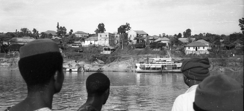
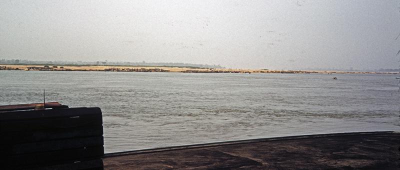
In the early 1960s, travel across the river by earthbound human beings required river ferries of various sizes (though a Federal bridge-building project was in progress on the south side of the city by 1962). Below, a view from aboard the Vehicular Ferry looking toward the west toward various landing points at Asaba in 1961. The roadway leading down to the main Ferry landing can be glimpsed toward the right in the image.
A closer map view, below, shows the major features of the area in better detail. From the eastern riverfront wharf at Asaba where ferries of various sizes could dock, while a massive ferryboat run by the Nigerian Government provided the sole means of conveying vehicular traffic across the River at this time. Second, observe the mid-River sandbanks here labeled Ubom. This marks the ancient marketplace located along these sandbanks (called “Brockendon Island” at this location by early British explorers), marking the political boundary between canoe-running traders from Igala and Aboh who made major exchanges there (mostly north/south) during the 19th century [see Henderson 1972:65-6].

Ubom was the location where the bulk of precolonial Igala-Aboh trade occurred, largely bypassing the two Riverbank-Uplands towns and their respective riverside marketplaces. The first Europeans to follow the river downstream did not even hear the word “Onitsha”, though they did stop at “Kirree”, a marketplace located where Asaba faces the River. (See Chapter 2, “European-organized Invasions”.)
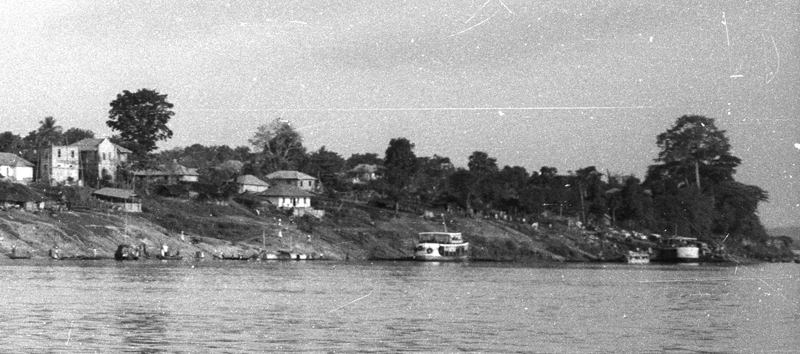
Below, a photograph of a private-enterprise river ferry stopped at the main Asaba passenger-landing dock (taken by Laurens Dawes in 1966). Note the small cramped concrete stairway at middle right, where passengers with their trade-goods are waiting to board, one small icon of the vast contrast between this historic city and that of the bustling world of Onitsha to be encountered below.

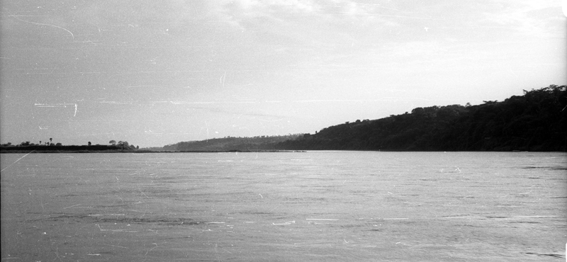
Below, the north-facing front beach at Asaba looked like this in March 1961, with a few boats docked alongside and one of several unpaved docks. This steep-sloping surface is roughly the shape of how the landing at “Kirree” must have appeared to the Landers Brothers when they were brought here in 1830 13. (The River’s course is diverted here from its generally SSW direction to a briefly more SW-ward one by these high banks.)
Below, a view taken just off the Niger River banks looking backward along the eastern front of 1960s Asaba, photographed from aboard a Ferry headed southeastward toward Onitsha. 14 Mostly-thatch-roofed houses of Asaba line the strong hillside, a geometry which looks very modest to a viewer accustomed to mountain ranges of the North American West, but its raised elevation as captured here was monumental, enough to prevent annual town floodings by the massive river. 
An iconic view: the olu-enu contrast
At left, on a ferry heading toward Onitsha in March 1961, a view near mid-river looking northeastward, you can see clearly how at far left the Anam Floodplain lies low and table-flat, with the mouth of the Anambra River near right-center, where it cuts against the rising hills of the Nsugbe Village-group (middle horizon) and near Onitsha the Forest Reserve (far right) which highlight the prime topographical intersections occurring at this point.
Here is a view from the Akpaka Uplands north of Onitsha lookiing roughly northward with the road to Nsugbe visible at right center. In the far distance are more lowlands, the locales of people M.D.W. Jeffreys called “Olu” or “Igbo Adegbe” fertile lands drained by the Mamu River and smaller tributaries of the Anambra. These people have historically provided food for those of the uplands where lands are less fertile. 15
Below , moving further downriver a view from the vehicular Ferry taken from mid-River south and east of the Ubom in September 1960 looking back toward the northwest toward the sandy expanse now visible and stretching across the entire mid-line of the photo. The Asaba hills show above and behind it as a thin horizontal blue line. Note the patches of dark color stretching along the Ubom banks. What looks from a distance like a long pile of debris is actually a quite substantial (if impermanent) “city” — the Ubom encampments of canoes coming from south as well as north, the 20th-century vesrion of that old pattern of itinerant traders camped in their canoes.
Below, a zoomed view of one patch of the Ubom as seen from this vantage point. Each of the small strips of huts and canoes scattered along here is an ephemeral hamlet of Ndi-Olu traders, what might be viewed as remnant continuities of that old Sandbank Marketplace, groups of traders still plying their trade safe from uplands interference (but now oriented largely to the Onitsha Main Market rather than further downstream). Note the cylindrical covers of some canoes, which convert them into housing for the travelers.

Retrospectively (since I did not think of this durinng my main period of active research into omitsha), it’s of interest that these riverain traders stayed in that distant location far across the river, instead of finding accommodation and technical support in Onitsha proper.. Obviously, this would be far more expensive, would require arranging safe accommodationss in Onitsha proper for their goods, their vehicles, and themselves. And from the Onitsha side, an entire new array of real estate and technical services would have to be mobilized. Tthe Onitsha market side provided almost technical services for small-scale riverain craftsmen.
Turning very briefly to the geo-economic implications of what we have just seen,
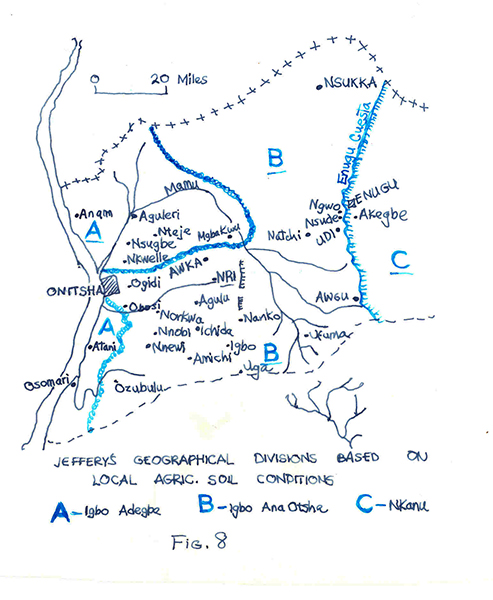
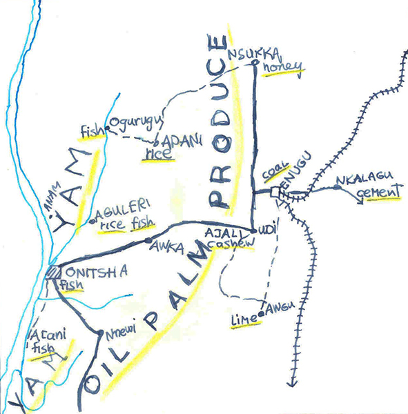
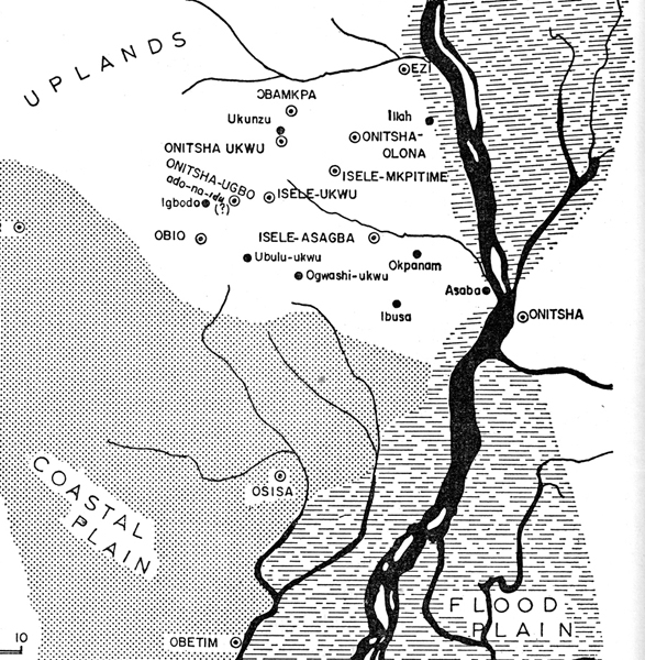
At left, the 1920s ethnographer M.D.W. Jeffreys provided an interesting map outlining an overview of the geography here, while a local Onye-igbo scholar, Mr. Oduah,, working out of the University of Nsukka in 1960, gives here a very broad picture of the differeing economi productions of the two major regions: roughly speaking, lowlands production of yams, rice, and fish while the uplands produce great quantities of palm oil.
This very brief summary lays a basis for more detailed consideration of the contrasts betwen “Olu” and “enu” (historically rephrased in Igbo as “igbo-na-oluI”), and also serves to introduce the next topic: the Onitsha urban sociocultural contrast of “Otu” and “Enu” (though these contrasts construe differences operating at more complicated levels).
- Map image cropped from Henderson 1972:38. [↩]
- Cropped from Henderson 1972:38 [↩]
- See Henderson 1972:pp. 44-6. [↩]
- Cropped from Map of Nigeria Eastern Region Population 1953, Fed Survey Dept. Lagos 1956. [↩]
- Ottenberg 1958 [↩]
- Henderson 1972: ;65-73 [↩]
- Map at above-left cropped from Henderson 1972:67. [↩]
- See Henderson 1972:40-41. Assertions of this kind have been sharply contested among some historians, prominent among them the late historian Professor Adele Afigbo. Dr. Afigbo wrote copiously and often brilliantly on the subject (e.g. his book of essays 2005), but some of his judgments were distractingly colored by his partisan ethno-political stance (seeking to extend ndi-Igbo “national” identifications into the ancient past). I have more to say on these issues elsewhere in this volume. [↩]
- Salman Rushdie, 2012, “The disappeared”, The New Yorker Sep. 17, p. 37. [↩]
- 2010: Trenton, NJ. [↩]
- See DeClezio 1997. [↩]
- The map below is derived from Federal Survey Department Nigeria 1958 250/141/12-58 Sheet 300. [↩]
- See Chapter two, “European-organized Invasions”). [↩]
- Photo by Laurens Dawes, 1966. [↩]
- See Jeffreys 1936: chapter two. [↩]